
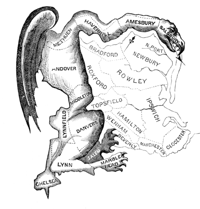
Gerrymandering is getting a lot of attention lately. Republican states such as Florida and Texas have been redrawing the lines of their Congressional districts in an attempt to boost their electoral prospects in the upcoming midterm elections. Democratic-led states such as California are fighting fire with fire by doing the same.
But gerrymandering is not just something that other states or Republicans do. It is a problem right here in New Jersey too. In early 2022, after Jersey City redrew the lines for the six wards that make up its voting districts, multiple community groups and residents alleged improper political gerrymandering and went to court to get the electoral map struck down and redrawn. Their lawsuit ultimately failed but the plaintiffs and New Jersey Appleseed, which represented them in the case (along with other attorneys), have now shifted their focus to changing New Jersey’s Municipal Ward Law so that something similar cannot happen again—in Jersey City, or elsewhere in the state.
On June 24, 2026, they achieved politically what had eluded them via the courts, when the City Council for Jersey City unanimously adopted Ordinance 26-044, which mandates sweeping reforms to the City’s ward redistricting process. The landmark ordinance establishes binding fairness standards regarding communities of interest, requires robust public hearings, and provides metrics for geographic compactness, which was a central issue in the litigation.
Statewide changes, however, remain necessary. Of NJ’s 564 municipalities, an estimated 60 or more of varying sizes throughout the state, also utilize a ward system. They include NJ’s largest cities such as Newark, Trenton, Paterson, Elizabeth and Camden, and smaller places like Montclair, Morristown, Plainfield, Clinton, Rahway and Gloucester City. A change to the state law that governs ward redistricting would put guardrails in place to protect against future gerrymandering in all of those places.
A Long History of Gerrymandering
What exactly is “gerrymandering”?
Wikipedia defines it as “the political manipulation of electoral district boundaries to advantage a party, group, or socioeconomic class within the constituency.”
It occurs in the course of redistricting aka the redrawing of electoral maps, which is typically done every 10 years, based on the population counts from the most recent U.S. Census. The next Census is scheduled for 2030, which means redistricting will next take place in 2031, five years from now.
Generally accepted redistricting criteria require that each district should be contiguous, compact, contain roughly the same number of people and avoid dividing so-called “communities of interest,” a term for geographically cohesive groups with distinctive characteristics whose political voice would be diluted if they were split among multiple voting districts. Those shared “community” characteristics can be a common race, culture, history, language, religion, etc.
Within those broad outlines, there has been a lot of leeway in how the lines are drawn. It is done in different ways in different places—often by a state legislature or a special commission formed for that purpose, which is how NJ does it for congressional and state legislative districts, as well as for each municipality that is comprised of wards.
The word “gerrymander” dates back to 1812. It was coined by a journalist in reaction to the redrawing of Massachusetts’ state senate election districts under Gov. Elbridge Gerry, with one district so oddly shaped that it resembled a salamander. “Gerry-mander” is a mashup of Gerry’s name and that of the amphibian. (Gerry went on to serve as Vice President under President James Madison.)
That was not even the first instance, however. Gerrymandering was done even earlier, before there was a word for it. In 1788, Patrick Henry, the first governor of Virginia (yes!, that Patrick Henry, the Founding Father who famously declared “Give me liberty, or give me death!”), intentionally drew a Virginia district to try to block James Madison (yes, the Founding Father who became the fourth President, from 1809 to 1817) from winning a seat in the first U.S. Congress. Henry, an anti-Federalist, had disagreements with Madison, a Federalist, about the U.S. Constitution, which was then in the process of being ratified by the states.
Henry’s efforts are considered the first partisan gerrymander—done for the purpose of empowering a particular political party—something we are seeing a lot now on the national level. Partisan gerrymandering is how a state like Maryland, where about a third of voters are registered Republicans had six Democrats in Congress and only one Republican. It is also the reason that North Carolina, a swing state that usually splits close to 50-50 between Democrats and Republicans in presidential elections, has 10 Republicans in Congress and only four Democrats. (A new map adopted there in October 2025, is expected to push the Republican advantage in North Carolina even further, giving them 11 seats to the Democrats’ three.)
There is another important type of gerrymandering—so entwined with the partisan sort that it can be difficult if not impossible to separate out—gerrymandering based on race. Because Black voters tend to vote for Democrats, the elimination of a Democratic district can often result in the elimination of a black Congressional representative, which is all the more harmful for exacerbating the underrepresentation of Blacks in Congress. Two common gerrymandering methods used to achieve this are known as “packing” and “cracking.” In “packing,” the lines are drawn to concentrate a particular group in a single district which they are thus more likely to win, perhaps overwhelmingly, but at the cost of diluting their voting strength elsewhere. “Cracking,” on the other hand involves dividing up a strong bloc of voters by scattering them into multiple districts, diluting their strength everywhere and possibly leaving them unable to win anywhere. Either way, you can and sometimes do end up with very strangely shaped districts.
Perhaps the most salient criticism of gerrymandering is that it is fundamentally undemocratic in that it allows government officials to pick their voters when it is supposed to be the voters who choose who gets to hold public office.
Gerrymandering in the Courts
Courts were initially reluctant to decide redistricting challenges, viewing the disputes as political in nature. But that changed following the 1962 decision in Baker v. Carr, 369 U.S. 186 (1962), where the U.S. Supreme Court found such cases justiciable, holding that federal courts had subject matter jurisdiction over lawsuits alleging that legislative maps could violate the 14th Amendment’s Equal Protection Clause when districts were of unequal size. Two years later, Baker was followed by Reynolds v. Sims, 377 U.S. 533 (1964), which mandated that legislative districts at both state and federal levels be roughly equal in population, based on the underlying principle of “one person, one vote.”
Then, in 1993, Shaw v. Reno, 509 U.S. 360 (1993), established that congressional districts drawn primarily on the basis of race are unconstitutional and subject to strict scrutiny under the Equal Protection Clause. Federal courts proceeded to hear cases challenging redistricting on the grounds that the lines had been drawn to dilute, cancel, or maximize the voting power of a specific racial or ethnic group.
In the 1986 case ofDavis v. Bandemer, 479 U.S. 109, the Court had ruled for the first time that partisan gerrymandering could theoretically violate the Constitution. However, the Justices could not agree on a standardized, mathematical test to prove it, meaning almost no maps were struck down subsequently. But in 2019, Rucho v. Common Cause, 588 U.S. ___ (2019), overruled Davis in a 5-4 decision. The Rucho Court stated that, although partisan gerrymandering is “inconsistent with democratic principles,” federal courts lacked authority to police or strike down maps based on partisan bias. The Court declared it a nonjusticiable political question, slamming the door to the federal courts on such cases.
Partisan gerrymandering suits could still be brought in some state courts but New Jersey has not yet been among them, as shown in Steinhardt v. New Jersey Districting Commission, 249 N.J. 561 (2022). There, the NJ Supreme Court dismissed a Republican challenge to the current NJ Congressional map, stating:
It is not the Court’s task to decide whether one map is fairer or better than another. We review redistricting plans only to determine if the map selected is “unlawful.” . . . So long as the final map is constitutional, the Court cannot grant any relief. Id. at 569.
In those states that do recognize claims of partisan gerrymandering, the concept of compactness has played an essential role in determining whether partisan gerrymandering had occurred, as it did, for example, in League of Women Voters v. Commonwealth of Pennsylvania, 178 A. 3d 737 (Pa. 2018).
Until recently, federal courts remained open to redistricting challenges based on race but the landscape for such cases shifted dramatically on April 29, 2026, with the U.S. Supreme Court decision in Louisiana v. Callais. The Court there struck down a map that had created another black majority Congressional district for the State of Louisiana, so that there would be two out of six altogether, mirroring the demographics of the state, which is roughly one-third black. That map had been meant to remedy racial vote dilution after a court struck down the original map based on the 2020 census, which had only one black majority district. But the Supreme Court departed from prior law under the Voting Rights Act by deeming the new map, drawn to correct a racial disparity, as itself an unconstitutional racial gerrymander. Courts had previously allowed the creation of minority majority districts but it will be much more difficult, if not impossible, to do so going forward
Redistricting in New Jersey
Now we look at New Jersey, which, every 10 years, utilizes a 10-member Apportionment Commission to redraw state legislative maps and a 12-member Redistricting Commission to redraw Congressional maps.
Apportionment Commission members are appointed five each by the chairs of the two largest parties, who are supposed to aim for geographic representation of all areas of the state. N.J. Constitution Art. IV, sec. III. There is no requirement for public hearings.
On the Redistricting side, Art. II, sec. II of the state Constitution provides that the 12 members are appointed, “with due consideration to geographic, ethnic and racial diversity,” as follows: two each by the Senate President and minority leader, Assembly Speaker and minority leader, and each of the two major party chairs. The 12 appointees vote for a 13th commissioner to serve as chair. If they cannot agree on who, the Supreme Court decides. The chair must have resided in New Jersey for at least the last five years and must not have held public or party office during that time.
Approval of a final Congressional map requires a simple majority and, if the commission cannot achieve one, the Supreme Court chooses which of the two plans with the most votes better conforms to the N.J. Constitution and federal laws. There must be at least three public hearings in different parts of the state and the final vote must be done by roll call at an open public meeting held on at least 24 hours’ notice. The state Constitution itself does not contain criteria beyond that, but the John R. Lewis Voter Empowerment Act of New Jersey, P.L.2026, c.31, signed into law on July 2, 2026, prohibits vote dilution that impacts a protected class and requires any policy or practice that burdens the right to vote to be justified by a compelling State interest, the strictest legal standard. In addition, the redistricting process, as in all states, is subject to the criteria embodied in the U.S. Constitution and federal statutes, along with the case law interpreting them, including compactness, population equality and whatever remains of the U.S. Voting Rights Act.
The process of line-drawing for Jersey City wards, as for other N.J. cities with a ward system, is governed by the state Municipal Ward Law, N.J.S.A. 40:44-9 to 18, or the MWL. It requires each municipality to create a Ward Commission, comprised of the members of the county board of elections as well the City Clerk. Commissions are required to meet in public within three months after the Governor promulgates the results of the latest decennial census and to draw wards formed of “compact and contiguous territory,” with the population of the most populous ward not differing from the population of the least populous ward by more than 10% of the mean. A commission has 30 days to complete the line-drawing and file a report and map with the office of the County Clerk, along with the Secretary of State and the Municipal Clerk’s office. Publication of notice of the ward boundaries in a local newspaper is required within two weeks after that.
The Lawsuit over the Jersey City Map
Following the promulgation of the 2020 Census results in September 2021, the Jersey City Ward Commission held its initial meeting on December 15, 2021, and adopted the disputed map on January 22, 2022. It filed the map on February 3 and publication occurred two days later.
Widespread public outrage over the map ensued, leading to the filing of Jersey City United Against the New Ward Map v. Jersey City Ward Commission, No. HUD-L-960-22 in Hudson County Superior Court on March 21, 2022.
The plaintiffs were three coalitions—the Downtown Coalition of Neighborhood Associations, the Democratic Political Alliance and Jersey City United Against the New Ward Map—as well as multiple neighborhood and block associations from across the entire City: the Greenville Neighborhood Alliance, Friends of Berry Lane Park, Lafayette Neighborhood Association, Pershing Field Neighborhood Association, Sgt. Anthony Neighborhood Association, Gardner Avenue Block Association, Lincoln Park Neighborhood Watch, Morris Canal Redevelopment CDC, Harmon Street Block Association and Crescent Avenue Block Association. Another plaintiff was Ward F Councilman Frank Gilmore, who sued in his individual and official capacities, alleging that Ward F, to which he had just been elected in November 2021, was grossly reconfigured in the newly redrawn map and that this was done to remove his supporters in retaliation for his advocacy on their behalf for more affordable housing.
The lawsuit, the first-of-its-kind in New Jersey, alleged problems with both the substance of the map and the process by which it was drawn. It claimed the map created two grossly non-compact wards while it carved up long-standing city neighborhoods, ignored natural geographic dividers, and split not only longstanding communities of interest but even several buildings.
For example, one of the divided areas was the historic Lafayette neighborhood, a community of interest with common economic, housing, cultural, and environmental interests. It is one of the oldest African-American communities in New Jersey, and includes the Pullman’s Porters’ House, an African slave burial ground, and St. John’s African Methodist Episcopal Church, which served as a stop on the Underground Railroad. A base of support for Gilmore, the neighborhood was “split through the heart” by the new map and the “fractured remainder” is now combined with a downtown area containing wealthier white and Asian residents “who do not share the same interests and priorities,” said the Complaint.
Further, the wards were not drawn compactly, as shown by low compactness scores under two commonly used mathematical measures. One of the newly drawn wards even had some resemblance to the original salamander-shaped district that gave gerrymandering its name, as seen in the illustration below. As a result of these alleged flaws, the plaintiffs claimed the map violated not only the MWL, but the NJ Civil Rights Act (CRA) and state constitutional rights to free speech, association, and equal protection.
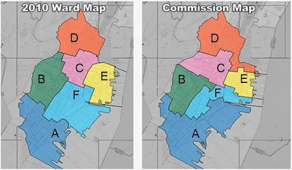
The Complaint further alleged that the gross reconfiguring of Ward F, represented by Gilmore, was done in retaliation for Gilmore’s support for more affordable housing and his opposition to certain proposed developments. The redrawn lines removed several projects from Ward F, which the plaintiffs allege was done “to significantly reduce his ability to influence their development” and removed the entire federal opportunity zone from his ward, thus limiting his influence on future development. Evidence in support of this retaliation/partisan gerrymandering count was the fact that the Jersey Ward Commission used election districts rather than the census blocks that are typically used in redistricting and were used in other municipalities in Hudson County, as the basis for drawing the ward lines. Plaintiffs alleged that election districts were used so they knew how people had voted in the previous municipal election in which Gilmore had defeated Mayor Fulop’s preferred candidate. They further claimed that this deprived him and his constituents of a constitutionally protected civil right and violated the CRA.
During the Ward Commission hearings, Gilmore was allegedly not shown a copy of a proposed new map until just two days before a hearing on it, even though the map was circulated to other Council members a week beforehand. The map allegedly sparked “outrage,” on account of how it impacted several wards but it did not go to a vote because the Commission meeting held on January 14 to consider its adoption was canceled due to technical difficulties. Eight days later, on January 22, the Commission met again and approved a different map,but one that was still gerrymandered and hostile to Gilmore and to the residents of Ward F who had just elected him two months earlier. The Complaint asserts, on information and belief, that the intervening changes resulted from meetings Commissioners had with connected stakeholders during the interim. This demonstrated “the arbitrary, capricious, impermissible and illegal nature of the Commission’s work,” plaintiffs alleged.
The way that the Commission went about adopting the map also drew a claim under the Open Public Meetings Act (OPMA). Plaintiffs alleged that “working session meetings” attended by a majority of the Commission took place where they engaged in deliberation and decision-making without public notice or opportunity to participate, even though Commission meetings are supposed to be open to the public. The subsequent adoption of an already-decided-upon map at the public meeting on January 22 did not remedy the OPMA violation, according to the plaintiffs.
The lawsuit asked the court to invalidate the map for violating the Municipal Ward Law and the N.J. Constitution, to declare that the free speech and associational rights of Gilmore and the Ward F residents had been violated and to order the map redrawn by a reasonable deadline in a manner that complied with statutory law and constitutional requirements.
Two months after the case was filed, in May 2022, the defendants moved to dismiss it for failure to state a claim. The lower court judge agreed and threw out the case in August 2022. It was not an unexpected result given that no similar case had ever been brought in NJ and the trial judge had no precedent for granting the relief sought.
The plaintiffs appealed to the Appellate Division. They contended that the suit raised significant legal issues and posited serious constitutional harms concerning the right of voters to fair and effective representation and that the court had an obligation to protect voters from the abusive maneuvering alleged, which had caused serious harm to the social and political fabric of Jersey City. The fact that no New Jersey court had dealt with the MWL or the New Jersey Constitution in the context of allegations of partisan gerrymandering was no excuse to abdicate the court’s responsibility to voters and residents of Jersey City, and it was no excuse to effectively render the Municipal Ward Law meaningless, they contended.
Nevertheless, in March 2024, the Appellate Division affirmed the dismissal of claims under the New Jersey Constitution, the Civil Rights Act and the Open Public Meetings Act. It did, however, allow a limited remand on the claim that the redistricting violated the MWL requirement that districts be compact but the court prohibited the use of commonly accepted standards of compactness in making that determination, requiring only a rational basis to uphold the map. The ruling effectively rendered the MWL’s “compactness” mandate meaningless and of no functional import, despite the profound implication on Plaintiffs’ fundamental right to vote, said the plaintiffs.
They then asked the NJ Supreme Court to review the case and on September 27, 2024, New Jersey’s top court granted the petition for certification and set an expedited briefing schedule so that the case could be decided in advance of the 2025 elections.
Six groups filed amicus briefs in the appeal, three on each side. Aligned with the plaintiffs were the ACLU-NJ, League of Women Voters of NJ and the Electoral Innovation Lab, a Princeton-based non-profit, non-partisan group that works for electoral reform using data-driven mathematical approaches. Siding with the Commission were the NJ League of Municipalities, whose brief was joined by the NJ Association of Counties and NJ Institute of Local Government Attorneys; the NJ Association of Election Officials; and the City of Jersey City, whose brief was joined by Councilman-at-Large Daniel Rivera.
The Supreme Court affirmed on June 18, 2025, in a deeply disappointing opinion that upheld the map but disagreed that additional factfinding was needed to determine if it met the compactness requirement. The Court further ruled that the Commission was not required to use mathematical measures when assessing compactness nor was it required to consider the impact of its map on communities of interest. Further, the Court deemed the wards sufficiently compact and not bizarrely shaped and thus found no violation of the MWL. The Court likewise rejected the Equal Protection claim under the state constitution as well as the N.J. Civil Rights Act claim.
Three of the seven Justices dissented in part in an opinion authored by Justice Rachel Wainer Apter, who deemed a remand on compactness justified and rejected the Appellate Division’s rational basis test as not supported by the MWL or case law. Given plaintiffs’ allegation that the 2022 map was much less compact than the 2012 map pursuant to two mathematical measures and the eyeball test, and that the Commission had not explained why, Wainer Apter said the Commission should be required to redraw the map to meet the MWL’s compactness requirement unless it could explain why redrawing the wards to address the population deviation between Wards E and D required such a drastic decline in compactness for all six wards “If a ward commission draws a new ward map that is substantially less compact than the previous map, that change could suggest that the commission did not adequately consider compactness or inappropriately subordinated it to extra-statutory considerations,” she wrote.
Wainer Apter accused the majority of devaluing the statute’s compactness requirement by deeming it “an elusive concept,” pointing out that the precedent cited by the majority in support had to do not with municipal redistricting, but legislative redistricting, for which it is far more challenging to draw compact districts.
The plaintiffs’ lawyers, Renée Steinhagen of NJ Appleseed Public Interest Law Center, Yael Bromberg of Bromberg Law, and Bill Matsikoudis of Matsikoudis & Fanciullo, responded to the ruling with a joint statement that the Court “allowed a gerrymandered map to stand in Jersey City, diluting the strength of the Municipal Ward Law, thereby creating new precedent which dilutes the right to fair and effective representation on the local level.”
The attorneys said they agreed with the three dissenting justices, who they noted were the newest members of the Court, and remarked that the majority effectively “devalued” the importance of compactness in the drawing of municipal wards, and “that this statutory requirement is all the more critical on the local level where neighbors rely on their representatives to advocate for issues of concern in their section of a municipality.” It is also “the very reason that city council wards exist.”
Similar criticism of the Court’s opinion appeared in a Harvard Law Review Note about the case. Referring to the MWL’s compactness proviso as “a judicially unmanageable requirement,” the Note faulted the Court for failing to come up with a workable standard:
the Jersey City United court should have devised a manageable test that implements the MWL’s compactness requirement. Instead, the court adopted a “bizarre[ness]” standard, which is no more manageable than the statutory compactness requirement itself is and provides little guidance to lower courts, legislatures, and municipalities. In the process, the court overlooked several alternative doctrinal approaches that would have more faithfully implemented the statute while addressing administrability concerns and preserving appropriate deference to legislatures.
Note, Jersey City United Against the New Ward Map v. Jersey City Ward Commission, 139 Harv. L. Rev. 1714 (May 2026).
An irony of the Supreme Court’s holding is that it rejected the use of objective statistical measures to evaluate “compactness,” one of which was devised by a Rutgers University political science Professor, the late Ernest Reock Jr.., director of the Center for Government Services and author of the New Jersey Legislative District Data Book, containing maps, descriptions and a wide range of statistical data on each of New Jersey’s 40 legislative districts and the municipalities comprising them. Professor Reock was cited by Justice John Paul Stevens in his concurring opinion in Karcher v. Daggett, 462 U.S.725 (1983), where the Supreme Court, in a case that arose from New Jersey, set up clear standards regarding burden of proof for handling a gerrymandering claim. Justice Stevens’ opinion noted the importance of using statistical measures to give effect and meaning to the notion of compactness.
Going Forward
Having taken the matter as far as it could go in the NJ courts and disappointed at their failure to construe the Municipal Ward Law in a manner that would uphold accepted principles of redistricting, the law and the Constitution, NJ Appleseed resolved to work on changing the law instead.
They successfully advocated for the newly enacted Jersey City ordinance, No. 26-944, which was unanimously adopted on June 24, 2026, two weeks after it was introduced. The ordinance states that it is intended to create a transparent process consistent with principles of redistricting developed in the courts for over 40 years, one that follows best practices and results in fair and effective representation for all Jersey City voters.
The WHEREAS language lists the multiple failures of the Ward Commission that the courts failed to recognize: failure to give adequate consideration to compactness; to allow for notice and public comment on a proposed map so as to allow sufficient time for community review; to take public testimony regarding communities of interest.; to use census blocks rather than voting districts to demarcate wards; to hold a public hearing to consider alternate ward maps; explain why it adopted a map that reduced the compactness and overall political coherence of Wards D and F.
It remedies those deficiencies by:
—requiring that wards be compact and contiguous;
—defining a compact ward as one whose boundaries are equidistant as possible from the center;
—allowing use of the Reock and Polsby-Popper statistical measures to evaluate compactness;
—requiring use of census blocks rather than voting districts to create wards;
—defining and mandating consideration of communities of interest;
—recognizing that OPMA applies to Ward Commission meetings and requiring adequate notice to enable review of proposed plans during and prior to the public comment period; at least one public meeting prior to approval with an opportunity to present alternative ward maps along with evidence concerning communities of interest and at which they discuss all plans being considered and invite both oral and written public comment; and
—requiring that the filed written report on ward boundaries be accompanied by a map and state the reasons for adoption of that map, including how it satisfies both the MWL and ordinance criteria.
In casting their votes in favor of the ordinance, multiple Council members expressed their view that gerrymandering had in fact occurred, with one calling it “despicable” and another asserting that it was “politically motivated.” Councilman Jake Ephros commented that the ordinance touched racial and economic justice as well as political power, while Gilmore acknowledged that although he had been targeted, the ordinance was not about him but a matter of what was equitable, right, fair and transparent. Councilmen Thomas Zuppa Jr. and Rolando Lovarro Jr. emphasized the importance of having the ordinance guidelines in place to prevent a recurrence. Several thanked NJ Appleseed and its Executive Director Renée Steinhagen, along with others, for their work on the issue.
The ordinance should prevent the same sort of gerrymandering in the future with regard to drawing Jersey City ward maps. To achieve the same goal statewide, it will be necessary to amend the MWL. That will be a more time-consuming and complicated endeavor but, depending on what protections the Legislature enacts, the hope is to outlaw gerrymandering throughout the state, at least on the municipal level.

